Friday, February 24, 2012
2012 Mt Taylor Winter Quadrathlon
VIDEO: http://www.youtube.com/watch?v=lyQPCEuTqtQ
My second time participating in this event did not disappoint. In my view, continues to be very well organized and the volunteers were terrific at every stage of the race. I had set a high goal for my performance this second time and I will summarize below. But first a little overview of the event for those not familiar with the Mt Taylor Winter Quadrathlon.
The Quadrathlon or Quad as its referred is a 43 mile race in Grants, NM which is 70 miles West of Albuquerque on I40. The starting point is in the city which is at an elevation of 6,500 feet and ultimately climbs to the spectacular 11,301 foot summit of Mt. Taylor, and then returns back to the finish line in Grants. We start with a 13 mile bike ride on a paved road. The course initially winds through the streets of Grants then begins an 1800 foot climb from desert cactus to ponderosa pine. At the end of the paved road, bikes are parked and then racers must run 5 miles on gravel roads. This part of the course climbs 1200 feet in elevation. Runners then turn to cross-country skis for 2 miles for another 1200 foot climb. The remaining 1 mile climb on snowshoes gains 600 feet to reach the summit. The race is only half way over as one must reverse the four events and race back 22 miles back to Grants. Total distance 43 miles.
I hope to give an overview of the Quad to share my experience and hopefully encourage someone else to give it a try. More at http://www.mttaylorquad.org/
Having done the race last year, I felt much more prepared and changed a few things to try to improve my time. For one, I purchased some cross-country skis at REI in Albuquerque while passing through on the way to a ski vacation in December. I had rented the skis last year prior to the event which gave me no chance to train with them. This year we went to Angel Fire Resort and got to try them out in the early AM for a couple of days. I found out that with no skins, I had a hard time controlling my speed and stopping was very difficult. In January, I went up to Ruidoso and again took out the skis and felt more comfortable going downhill, but still fell a few times. Not a good omen. I practiced on the bike going up trans mountain and have been running a lot training for the NY Marathon and the El Paso Half-Marathon.
Pre-Race
The drive to Grants, NM is about 312 miles with a shortcut at Los Lunas which goes around Albuquerque and took me about 4 and a half hours. Arrived to the hotel and packed my transition bags to check them in. One bag was for the bike/run transition and included the shoes, water bottle, and some Gu. The other bag was for the ski boots, snow shoes, skis, poles, and more gu. Went out to the Cibola County Convention Center and got my race numbers (119) and T-shirt. After that, went to the fire station to turn in the gear that would be taken up to the mountain the next morning for me. Everything is labeled with yellow tape for the first transition and red tape for the second transition. After taking care of that, went out to grab the spaghetti dinner that was served in the Grants High School cafeteria. That night I got the GoPro Helmet camera I recently acquired configured to record portions of the race and from which the You Tube Video was made.
Race Morning
Woke up at 0500 and got everything packed for checkout of the room. Went to grab hotel breakfast and then out to the convention center with bike. The temperature on car thermostat was 23F. The wind was about 10-15 mph but it was coming down from the mountain. There were 119 male and 30 female soloists and 32 teams.I lined up for the 0800 start of the soloists, the teams started at 0900. At 0800, the horn was sounded and we were off.
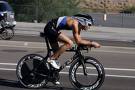
The Bike The Bike (13 miles, 1800 feet climb, 1:19:18 including bike/run transition at 8200 feet)
The bike started pretty flat and slow with all the riders. The group started to split during the initial climbs which at first were 2% and then got a little harder. There was a short downhill half way up and then the last 4 miles was 8-10% grade with somewhat of a head wind. The views were spectacular on this portion and the snow level was lower in the mountain from last year. I reached the end of the bike portion and a volunteer called my number as I arrived. They then guided me to my spot to leave the bike and there was my transition bag. I got my shoes on and then put on by drink carrier, gu's and hat and I was off on the run. The transition was delayed by the transfer of the GoPro camera from the helmet to a head strap system.
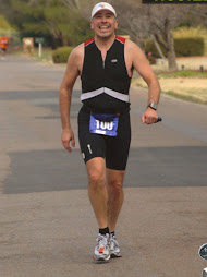
The Run (5 miles, 1200 foot climb, 1:11:56 including run/ski transition at 9,497 feet)
The run initially was pretty flat and there were some initial downhills on gravel roads. There was a bit of snow and slush at first then more as we ascended further. I stuck to my run/walk routine to conserve energy. As I got higher it got harder and was forced to take more walk breaks. This year they added an additional aid stations so there were two. There was an aide station at the half way point with Gatorade, bananas, and orange slices. I also had a GU on the way with Gatorade from my carrier. Again, this year the snow pack on the road came much sooner and we ran a significant portion on snow.
I reached the run/ski transition and once again the volunteers were ready with my skis, poles, and boots. There was a volunteer assigned to a racer at each transition and they would bring water and orange slices to you as you put on the gear. I also got my snowshoes on the backpack to carry up to the next transition.
The Cross-Country Ski (2 miles, 1200 foot climb, 49:32 including ski/snowshoe transition at 10,700 feet)

This time again I used the climbing skins and they made all the difference. I was able to move at a pretty good clip and got a good rhythm. I had learned well from watching those instructional You Tube videos. At first the course is not too steep, but as with every other time, at the end it gets hard before transition. The notorious 'Heart Break Hill" lived up to its name as it was a barren exposed area of the mountain with winds this year that were not as bad as last year. The views at this point were spectacular and I made a point to look around to enjoy the scenery. At the end of the last hill we arrived at the transition. We had to just find any place to leave the skis and put on the snowshoes for the next climb.
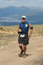
The Snowshoe (1 mile, 600 feet climb, 42:50 to reach 11,301 foot summit)
Again at the beginning of this portion, it was a slight incline with two way traffic as people were coming down from sumitting. The last 4/10th of a mile was the hardest as we climbed at 20-30% grade according to my Garmin to the summit of Mt Taylor. The view from the summit was spectacular. There was a wind blown American flag and a elevation marker. I spent a minute looking out to the Sandia Mountains next to Albuquerque in the distance. I was now half way done. It had taken me 4:03:34 to get to this point.

Snowshoe down (1 mile, 18:30)
The downhill portion was a different route initially and had really deep snow which made it more treacherous. On the way we passed the highest 'bar' where the offered Water or JD? Unlike last year, I chose to take a small amount of Jack Daniels, they gave me about a tablespoon in a small paper cut with a bit of water to chase it. They also had tequila available. I was remembering that I had read in the book "Born to Run" that the Tarahumara drink alcoholic beverages during their runs. I thought if it is good for the Tarahumara it is good enough for me. As I made it further down, it was nice to see there still some people still behind me heading up to the summit. Once, I arrived back in transition, I was assisted by a volunteer named Joseph who had camped there night before. They took off my skins and put them away for me as I had been snowshoeing.
Ski down (2 miles, 1:08:35 ouch! including snowshoe/ski transition)
Once again like last year, this portion of the Quad if I had to do over again I would do things differently. Last year, I had decided priory to keep the skins on for safety reasons and this made me very slow. Well this year with no skins it took me longer because I fell a total of 4 times. What made me slow down even more was that I got ice in the bindings of the skis and as such could not put my skiis on easily and lost more time. I had done more training with the skis but my legs were so tired by this point that I had a hard time controlling the descent.
Run Down (5 mile, 1:01:44 including ski/run transition)
Once we got back to the transition the volunteers were awesome again. As I arrived they had my running shoes ready and gave me orange slices and water. They then put away my skis, boots, poles, and pack with snowshoes. I started running down and found out my quads were getting pretty fatigued. There was a lot of mud and slush to contend with at first but by the end the gravel was dry and soft. Those slight downhills on the way up became big hills on the return trip. Took many walk breaks and spent some time at the aide station half way down.
The Bike Down (13 miles, 40:29 including run/bike transition)
As I arrived to the last transition, I was met up by a volunteer. She had my bike ready, my bike shoes at the ready as well. I replenished my Gatorade and had a gu before heading down. The conditions were excellent and I was able to go up to 32 mph on the downhill. Further, I had to contend with the slight uphill before again going slightly downhill into the wind which seemed to develop at the lower elevations.
I arrived into Grants and to the finish glad to have made it down in one piece. My total down time was 3:09:17 and the entire course took me 7:12:51. I ended up 97Th overall out of 117 men. In my age group, I was 15Th out of 17. I was happy overall with the exceptions of the downhill ski portion which I need to improve further. I was wondering to my fellow competitor whether they thought maybe that shot of JD had hurt my ability to ski and caused the falls and he replied. "On the contrary, it helped you because it kept you from feeling the pain!"

My second time participating in this event did not disappoint. In my view, continues to be very well organized and the volunteers were terrific at every stage of the race. I had set a high goal for my performance this second time and I will summarize below. But first a little overview of the event for those not familiar with the Mt Taylor Winter Quadrathlon.
The Quadrathlon or Quad as its referred is a 43 mile race in Grants, NM which is 70 miles West of Albuquerque on I40. The starting point is in the city which is at an elevation of 6,500 feet and ultimately climbs to the spectacular 11,301 foot summit of Mt. Taylor, and then returns back to the finish line in Grants. We start with a 13 mile bike ride on a paved road. The course initially winds through the streets of Grants then begins an 1800 foot climb from desert cactus to ponderosa pine. At the end of the paved road, bikes are parked and then racers must run 5 miles on gravel roads. This part of the course climbs 1200 feet in elevation. Runners then turn to cross-country skis for 2 miles for another 1200 foot climb. The remaining 1 mile climb on snowshoes gains 600 feet to reach the summit. The race is only half way over as one must reverse the four events and race back 22 miles back to Grants. Total distance 43 miles.
I hope to give an overview of the Quad to share my experience and hopefully encourage someone else to give it a try. More at http://www.mttaylorquad.org/
Having done the race last year, I felt much more prepared and changed a few things to try to improve my time. For one, I purchased some cross-country skis at REI in Albuquerque while passing through on the way to a ski vacation in December. I had rented the skis last year prior to the event which gave me no chance to train with them. This year we went to Angel Fire Resort and got to try them out in the early AM for a couple of days. I found out that with no skins, I had a hard time controlling my speed and stopping was very difficult. In January, I went up to Ruidoso and again took out the skis and felt more comfortable going downhill, but still fell a few times. Not a good omen. I practiced on the bike going up trans mountain and have been running a lot training for the NY Marathon and the El Paso Half-Marathon.
Pre-Race
The drive to Grants, NM is about 312 miles with a shortcut at Los Lunas which goes around Albuquerque and took me about 4 and a half hours. Arrived to the hotel and packed my transition bags to check them in. One bag was for the bike/run transition and included the shoes, water bottle, and some Gu. The other bag was for the ski boots, snow shoes, skis, poles, and more gu. Went out to the Cibola County Convention Center and got my race numbers (119) and T-shirt. After that, went to the fire station to turn in the gear that would be taken up to the mountain the next morning for me. Everything is labeled with yellow tape for the first transition and red tape for the second transition. After taking care of that, went out to grab the spaghetti dinner that was served in the Grants High School cafeteria. That night I got the GoPro Helmet camera I recently acquired configured to record portions of the race and from which the You Tube Video was made.
Race Morning
Woke up at 0500 and got everything packed for checkout of the room. Went to grab hotel breakfast and then out to the convention center with bike. The temperature on car thermostat was 23F. The wind was about 10-15 mph but it was coming down from the mountain. There were 119 male and 30 female soloists and 32 teams.I lined up for the 0800 start of the soloists, the teams started at 0900. At 0800, the horn was sounded and we were off.
The Bike The Bike (13 miles, 1800 feet climb, 1:19:18 including bike/run transition at 8200 feet)
The bike started pretty flat and slow with all the riders. The group started to split during the initial climbs which at first were 2% and then got a little harder. There was a short downhill half way up and then the last 4 miles was 8-10% grade with somewhat of a head wind. The views were spectacular on this portion and the snow level was lower in the mountain from last year. I reached the end of the bike portion and a volunteer called my number as I arrived. They then guided me to my spot to leave the bike and there was my transition bag. I got my shoes on and then put on by drink carrier, gu's and hat and I was off on the run. The transition was delayed by the transfer of the GoPro camera from the helmet to a head strap system.
The Run (5 miles, 1200 foot climb, 1:11:56 including run/ski transition at 9,497 feet)
The run initially was pretty flat and there were some initial downhills on gravel roads. There was a bit of snow and slush at first then more as we ascended further. I stuck to my run/walk routine to conserve energy. As I got higher it got harder and was forced to take more walk breaks. This year they added an additional aid stations so there were two. There was an aide station at the half way point with Gatorade, bananas, and orange slices. I also had a GU on the way with Gatorade from my carrier. Again, this year the snow pack on the road came much sooner and we ran a significant portion on snow.
I reached the run/ski transition and once again the volunteers were ready with my skis, poles, and boots. There was a volunteer assigned to a racer at each transition and they would bring water and orange slices to you as you put on the gear. I also got my snowshoes on the backpack to carry up to the next transition.
The Cross-Country Ski (2 miles, 1200 foot climb, 49:32 including ski/snowshoe transition at 10,700 feet)

This time again I used the climbing skins and they made all the difference. I was able to move at a pretty good clip and got a good rhythm. I had learned well from watching those instructional You Tube videos. At first the course is not too steep, but as with every other time, at the end it gets hard before transition. The notorious 'Heart Break Hill" lived up to its name as it was a barren exposed area of the mountain with winds this year that were not as bad as last year. The views at this point were spectacular and I made a point to look around to enjoy the scenery. At the end of the last hill we arrived at the transition. We had to just find any place to leave the skis and put on the snowshoes for the next climb.
The Snowshoe (1 mile, 600 feet climb, 42:50 to reach 11,301 foot summit)
Again at the beginning of this portion, it was a slight incline with two way traffic as people were coming down from sumitting. The last 4/10th of a mile was the hardest as we climbed at 20-30% grade according to my Garmin to the summit of Mt Taylor. The view from the summit was spectacular. There was a wind blown American flag and a elevation marker. I spent a minute looking out to the Sandia Mountains next to Albuquerque in the distance. I was now half way done. It had taken me 4:03:34 to get to this point.

Snowshoe down (1 mile, 18:30)
The downhill portion was a different route initially and had really deep snow which made it more treacherous. On the way we passed the highest 'bar' where the offered Water or JD? Unlike last year, I chose to take a small amount of Jack Daniels, they gave me about a tablespoon in a small paper cut with a bit of water to chase it. They also had tequila available. I was remembering that I had read in the book "Born to Run" that the Tarahumara drink alcoholic beverages during their runs. I thought if it is good for the Tarahumara it is good enough for me. As I made it further down, it was nice to see there still some people still behind me heading up to the summit. Once, I arrived back in transition, I was assisted by a volunteer named Joseph who had camped there night before. They took off my skins and put them away for me as I had been snowshoeing.
Ski down (2 miles, 1:08:35 ouch! including snowshoe/ski transition)
Once again like last year, this portion of the Quad if I had to do over again I would do things differently. Last year, I had decided priory to keep the skins on for safety reasons and this made me very slow. Well this year with no skins it took me longer because I fell a total of 4 times. What made me slow down even more was that I got ice in the bindings of the skis and as such could not put my skiis on easily and lost more time. I had done more training with the skis but my legs were so tired by this point that I had a hard time controlling the descent.
Run Down (5 mile, 1:01:44 including ski/run transition)
Once we got back to the transition the volunteers were awesome again. As I arrived they had my running shoes ready and gave me orange slices and water. They then put away my skis, boots, poles, and pack with snowshoes. I started running down and found out my quads were getting pretty fatigued. There was a lot of mud and slush to contend with at first but by the end the gravel was dry and soft. Those slight downhills on the way up became big hills on the return trip. Took many walk breaks and spent some time at the aide station half way down.
The Bike Down (13 miles, 40:29 including run/bike transition)
As I arrived to the last transition, I was met up by a volunteer. She had my bike ready, my bike shoes at the ready as well. I replenished my Gatorade and had a gu before heading down. The conditions were excellent and I was able to go up to 32 mph on the downhill. Further, I had to contend with the slight uphill before again going slightly downhill into the wind which seemed to develop at the lower elevations.
I arrived into Grants and to the finish glad to have made it down in one piece. My total down time was 3:09:17 and the entire course took me 7:12:51. I ended up 97Th overall out of 117 men. In my age group, I was 15Th out of 17. I was happy overall with the exceptions of the downhill ski portion which I need to improve further. I was wondering to my fellow competitor whether they thought maybe that shot of JD had hurt my ability to ski and caused the falls and he replied. "On the contrary, it helped you because it kept you from feeling the pain!"

Tuesday, January 17, 2012
2012 Puzzler Mountain Bike Race

I went to the Bowen Round House on Saturday and picked up the race packet and number. Paid for a 1 day race license and checked out the course. Sunday AM, drove out with the kids and their bikes in tow. I wanted to get a chance to ride around the course around Bowen ranch after the racers had taken off as I knew they would not be back for several hours. Signed in at the roster and rode up Mad Cow with the boys to warm up. They had a nice campground fire for us and we watched the 50 mile and 35 mile racers take off. The 10 mile fun riders were last to take off about 10 minutes later.
 |
| Top of only hill in 10 mile Fun Ride of Puzzler |
 |
| Plant I landed on top of, actually quite soft despite appearance |
 |
| Robert Newman, Mountain Bike trail builder |

After 7.5 miles, it was back to the Bowen Round House for some gatorade and then down Lazy Cow for another mile and then back along Pipeline back to the ranch to complete a 10 mile loop. My total time was 1:32:33 officially. I scanned the results on Tuesday after the race and to my surprise found out I was 2nd out of 17 finishers with 3 DNFs in the 10 mile category.
I think as always the race directors, David Wilson and Brent Sanders did a great job with the Puzzler race this year. I think the 10 mile course is a nice addition to get more people interested and get motivated to train for the longer events. I think a Kid's race would be a good addition along Lazy cow after all the 10 milers are back as there is plenty of "downtime" before the riders come back to the ranch. So now its on to the El Paso Half Marathon on Feb 5 and then Mt. Taylor Quadrathlon Feb 18 in Grants, NM, after that event I will have my next post.
Subscribe to:
Posts (Atom)